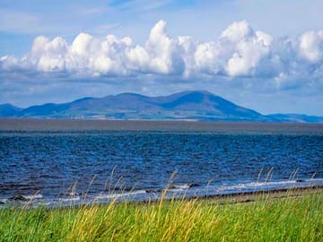
Allonby Bay Camping
Dieser Platz nimmt auf Pitchup.com gerade keine Buchungen entgegen.
Wenn Sie der Besitzer dieses Campingplatzes sind, können Sie mithilfe von Pitchup.com zusätzliche Buchungen erhalten.
Es ist kostenlos, schnell und einfach!
Art des Platzes
Gesprochene Sprachen
![]() Englisch
Englisch
Nächstgelegene Plätze

Leider gibt es in der Umgebung keine buchbaren Plätze.
The Lake District and Cumbria: Mehr übers Campen erfahren?
Ausstattung
![]() Mobiltoilette
Mobiltoilette
![]() Pop-up-Campingplatz
Pop-up-Campingplatz
![]() Hunde gestattet
Hunde gestattet
Freizeiteinrichtungen am Platz
Abendunterhaltung
Angeln
Bar oder Clubhaus
Eigenes Restaurant/Cafe
Fahrradverleih
Fernsehraum
Fitnesscenter
Freischwimmbecken
Gerichte zum Mitnehmen
Hallenbad
Kinderclub
Spielplatz
Spielzimmer
Tennis
Wassersport
Platzausstattung
Abholung vom Bahnhof/Busbahnhof
Auto-Parkmöglichkeit am Stellplatz/bei der Unterkunft
Badewanne vorhanden
Barrierefreie Einrichtungen
Dusche vorhanden
Eisbeutel-Kühlservice
Familienwaschräume
Geschirrspülraum
Gratis WLAN
Internet-Anschluss
Komposttoilette
Lebensmittelgeschäft
Mobiltoilette
Park für Hunde
Sanitärgebäude
Toiletten im Pub
Trockenraum
WLAN
Waschküche
Öffentliches Telefon
Gruppenregelungen
Familienfreundlich
Frauen-/Männergruppen willkommen
Motorradfreundlich
Studentengruppen willkommen
Regeln
Grill wird zur Verfügung gestellt
Grillen gestattet
Hunde ganzjährig gestattet
Hunde gestattet
Lagerfeuer gestattet
Nutzfahrzeuge gestattet
Themen
Eindrucksvolle Landschaft
Friedlich
Naturparadies
Wanderparadies
Ausstattung
Chemie-WC Entsorgung
Erneuerbare Energie
Gasflaschen-Service
Kein Warmwasser
Ladestation(en) für Elektroautos
Ladestationen
Recycling vorhanden
Einrichtungen in der Umgebung
Bar in der Nähe
Gassi gehen in der Nähe
Lebensmittelgeschäft in der Nähe
Öffentliche Transportmittel in der Nähe
Typ
Mittelgroß (26-50 Stellplätze)
Pop-up-Campingplatz
Freizeitaktivitäten in der Umgebung
Angeln in der Nähe
Radfahren in der Nähe
Restaurant in der Nähe
Lage
Allonby Bay Camping
Maryport
Allonby
Cumbria
England
CA15 6QQ
Zeitzone
Europe/London +0000 (GMT+00:00)
GPS
54,78426°N
-3,43057°W
Wegbeschreibung
Öffentliche Verkehrsmittel in der Nähe
Bitte beachten: Alle auf dieser Seite angegebenen Entfernungen sind auf "Luftlinien-Basis" berechnet - bitte die exakte Entfernung unter Berücksichtigung des Transportmittels mithilfe des Feldes Wegbeschreibung oben überprüfen.
Sehenswürdigkeiten in der Nähe
Wasserqualität umliegender Gewässer
| Name | Entfernung | Art | 2020 | 2019 | 2018 | 2017 |
|---|---|---|---|---|---|---|
| Allonby | 1,8 km | Meer | N/A | Gut | Gut | Gut |
| Southerness | 14,8 km | Meer | N/A | Gut | Gut | Ausgezeichnet |
| Sandyhills | 21,6 km | Meer | N/A | N/A | Mangelhaft | Mangelhaft |
| Rockcliffe | 25,1 km | Mündung | N/A | Mangelhaft | Mangelhaft | Mangelhaft |
| St Bees | 34,7 km | Meer | N/A | Ausgezeichnet | Ausgezeichnet | Ausgezeichnet |
Datenquelle: Europäische Umweltagentur
Must-see
John Paul Jones Cottage Museum & Visitor Centre 15,8 km
Mirehouse Historic House and Gardens 22,1 km
Whinlatter Forest & Visitor Centre 24,7 km
Castlerigg Stone Circle 29,4 km
Carlisle Castle 33,6 km
National Trust
Wordsworth House and Garden 14 km
Buttermere and Ennerdale 29,3 km
Wasdale, Eskdale and Duddon 40,4 km
Grasmere and Great Langdale 46,6 km
Radwege
Umliegende Radwege des Nationalen Radnetzes finden - über 19.000 Kilometer an Radwegen
Andere
Cockermouth - River Cocker 14,2 km
WORKINGTON HALL 17,2 km
Carsethorn - Powillimount - Arbigland 17,9 km
MERSEHEAD (CURRENT BOUNDARY FROM 04/11/2003) 18,3 km
CAMPFIELD MARSH (CURRENT BOUNDARY FROM 14/11/2006) 20,8 km
Bitte beachten: Alle auf dieser Seite angegebenen Entfernungen sind auf "Luftlinien-Basis" berechnet - bitte die exakte Entfernung unter Berücksichtigung des Transportmittels mithilfe des Feldes Wegbeschreibung oben überprüfen.
Bewertungen
Noch keine Bewertungen
- Gibt es im Allonby Bay Camping ein Schwimmbecken? Nein Alle Eigenschaften ansehen
- Ist Allonby Bay Camping hundefreundlich? Ja Alle Eigenschaften ansehen
- Welche Attraktionen finde ich in der Nähe von Allonby Bay Camping? Jump on your bike and in half an hour you can be strolling around the shops, eateries and harbour sights of Maryport, a local coastal town where there's also an aquarium by … Mehr erfahren
- Wann kann ich im Allonby Bay Camping ein- und auschecken?
Mehr erfahrenCamping und Reisen Ankunft: 15:00 – 20:00 Abreise bis: 11:00